"BEST OFFERS DEADLINE 12PM 8TH NOVEMBER 2024. Please contact the agent for more information.
A commercial mixed farm with a substantial range of buildings, Grade 2 arable land and salt marsh
Cockerham 2.2 miles, M6 Junction 33 5.5 miles, Garstang 7 miles, Lancaster 8 miles, Preston 22 miles
4 bedroom period farmhouse with 2 bedroom loft conversion
3 bedroom bungalow built in 2012 with 1 bedroom flat
Over 100,000 square feet of steel framed buildings including a 40 point rotary parlour
352 acres of Grade 2 grass or arable land
279 acres of salt marsh
About 650 acres 263 ha in all
Available as a whole or in up to five lots
Lot 1 Sand Villa Farm
4 bedroom farmhouse 3 bedroom bungalow Substantial range of farm buildings 40 point rotary parlour Arable land
About 27.35 acres 11.06 ha
Lot 2 Land at Sand Villa Farm
Arable land with access from Gulf Lane
About 133.11 acres 53.88 ha
Lot 3 Land off the A588
Arable land
About 135.83 acres 54.98 ha
Lot 4 Land off the A588
Arable land
About 68.40 acres 27.69 ha
Lot 5 Salt marsh
About 285.52 acres 115.54 ha
Sand Villa Farm
The farm has been in the same family for the past 17 years and up until April 2018, it operated as a working dairy with a herd of about 500 milking cows producing on average 9,500 litres per cow per year, sold through a contract with Meadow Foods. There are numerous other milk companies in the region. Since 2018, the owners have bought and sold cull cows from the farm which has required the daily use the De Laval rotary parlour.
The farm benefits from versatile Grade 2 soils which have been used predominantly for growing maize and grass silage as well as for livestock grazing. The farm also includes ownership of almost 280 acres of saltmarsh which lies adjacent to the farm, over the sea wall.
Lot 1 Sand Villa Farm
About 27.35 acres 11.06 ha
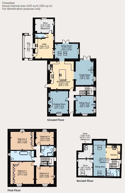
Sand Villa Farmhouse
This traditional farmhouse is of stone elevations under a slate roof. The house lies west of the farm buildings and benefits from a driveway, separate to those for the farm, from the A588. The front door leads into a hallway with two reception rooms off and leads through to the heart of the home being an open plan kitchen, dining and sitting room. There is also a utility room, boot room and cloakroom at the rear of the house.
On the first floor there are four double bedrooms and two bathrooms. Another staircase leads up to the second floor with a self contained annex comprising an open plan kitchen living area, a bathroom and two bedrooms.
The Meadows
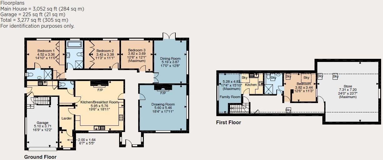
On the east side of the farm buildings lies The Meadows, a four bedroom bungalow subject to an agricultural occupancy condition, constructed by the vendors in 2015. The front door leads into a central hall and the two reception rooms on the right side, one of which has double doors on to a large decking to the rear. There is a large kitchen dining room with separate larder, cloakroom and utility room beside the side door. On the back of the house lies three bedrooms one ensuite and a family bathroom.
The loft of the bungalow has been converted to a self contained one bedroom flat with a kitchen and bathroom. The flat has independent access from the garage.
Farm Buildings
The buildings extend to over 100,000 square feet in total and have been extended and developed over time to offer large open areas of livestock accommodation, handling areas, the milking parlour, and stores. A detailed description of the buildings is available in our brochure.
South of the farm buildings lies an open silage clamp with reinforced concrete sides and earth bank retaining walls with a capacity for more than 5,500 tonnes. The neighbouring clay lined lagoon has capacity for approximately 2,500,000 gallons.
Land
There are approximately 17 acres of pasture paddocks surrounding the farm buildings, some with frontage on to the A588.
Lot 2 Land at Sand Villa Farm
Arable land with access from Gulf Lane
About 133.11 acres 53.88 ha
A central track from the rear of the farm buildings runs south to Gulf Lane offering access into all five fields of productive arable land and short term grass leys which form Lot 2. The land s layout provides for the efficient movement of livestock or machinery to and from the farm buildings Lot 1 . There are approximately 130 acres of farmable land within Lot 2, the remainder being the farm tracks, hedges and drainage ditches.
The land is classified as Grade 2 on the Agricultural Land Classification and soils are a loam over clay, recently cropped with grass leys, maize and rye.
Lot 3 Land off the A588
Arable land
About 135.83 acres 54.98 ha
This parcel of land lies mostly north of the A588, between the road and sea wall. There are five fields in total, all of which have been utilised by the vendors for arable cropping or grazing livestock. All fields have adequate sheep fencing.
There are several access gates from the A588, the main one being central within the land, positioned alongside the Mill House Pool, a watercourse that runs under the road, across the land and through the sea wall.
At the top end of the land lies a large pond surrounded by woodland. There are approximately 130 acres of farmable land within Lot 3. The land is classified as Grade 2 on the Agricultural Land Classification and soils are sandy, recently cropped with grass leys, maize and rye.
Lot 4 Land off the A588
Arable land
About 68.40 acres 27.69 ha
This lot comprises mostly arable land north of the A588, located on the opposite side to Sand Villa Farm. The land includes the access track from the road which runs along the western boundary up to the sea wall. If the farm is sold in lots, a right of way in favour of the salt marsh will need to be incorporated across this.
The land comprises one large arable field of 67 acres which is classified as Grade 2 on the Agricultural Land Classification and has recently grown grass leys, maize and rye.
Lot 5 Salt marsh
About 285.52 acres 115.54 ha
The saltmarsh is a large swathe of land north of the sea wall accessed by two stone tracks from the A588 across Lots 3 and 4. The land has an abundance of protected flora, fauna and wildlife and is sensitively managed by the vendors who graze it from May to September every year. There is also a 5 acre pasture field south of the sea wall to assist with moving and handling livestock on and off the marsh.
This lot is entered into a Mid Tier Countryside Stewardship Agreement from 1st January 2024 to 31st December 2028 which pays approximately £42,000 per annum under option code GS9 management of wet grassland for breeding waders .
General
Method of sale Sand Villa Farm is offered for sale as a whole, or in up to five lots by private treaty.
Tenure The property is sold freehold with vacant possession on completion. Subject to a lease to Sunbeam Ltd for the solar panel array on the roof of the farm buildings. This started in 2015 for a period of 20 years and provides the farm with reduced electricity bills.
Wayleaves, easements and rights of way The property is being sold subject to and with the benefit of all rights including; rights of way, whether public or private, light, support, drainage, water and electricity supplies and other rights and obligations, easements and quasi easements and restrictive covenants and all existing and proposed wayleaves for masts, pylons, stays, cables, drains, water and gas and other pipes whether referred to in these particulars or not.
There is one public footpath across part of the farm.
Basic Payment There are no Basic Payment entitlements included in the sale.
Schemes Lot 5 is entered into a Mid Tier Countryside Stewardship Agreement from 1st January 2024 until 31st December 2028. At the time of writing an application to enter the farm into a Sustainable Farming Incentive Scheme has been applied for. More information is available from the vendor s agent. The purchaser will be deemed to have full knowledge of the scheme s and will take them on and comply with them from completion if necessary. The vendor will retain any payments payable up to completion.
Designations The saltmarsh Lot 5 is within the Morecambe Bay Ramsar Site, a wetland designated to be of international importance under the Ramsar Convention. Lot 5 is also within the Lune Estuary Site of Special Scientific Interest, a Special Area of Conservation, Special Protection Area and a Marine Conservation Zone.
Holdover & Ingoing Valuation This may be required by the vendor, subject to the timing of completion.
Sporting, timber and mineral rights All timber and mineral rights are included in the freehold sale, in so far as they are owned. The sporting rights across part of Lot 1, Lots 3, 4 and 5 are reserved in favour of a local wildfowling group.
Fixtures and fittings All fixtures, fittings and equipment, including fitted carpets, curtains and farm equipment, are specifically excluded from the sale. These may be available to the purchaser by separate negotiation.
Covenants and or restrictions There are restrictions covenants listed on the Land Registry Title deed, details of which will be made available by the vendors solicitors on request.
Local authority Lancaster City Council lancaster.gov.uk
VAT Any guide price quoted or discussed is exclusive of VAT. In the event that a sale of the property, or any part of it, or any right attached to it, becomes a chargeable supply for the purposes of VAT, such tax will be payable in addition.
Health and safety Given the potential hazards of a working farm we ask you to be as vigilant as possible when making your inspection for your own personal safety, particularly around the farm buildings and machinery.
what3words Sand Villa Farmhouse brightens.senders.lengthen
Viewing Strictly by confirmed appointment with the vendor s agents, Strutt & Parker in Harrogate or London .
Sand Villa Farm is positioned in a coastal location in northwest Lancashire, between the county cities of Preston and Lancaster. The farm lies on flat productive land south of the River Lune in an agriculturally progressive part of the country, benefitting from Grade 2 land.
Locally, the closest villages are Cockerham, Stakepool and Pilling, all within 2.5 miles of farm and provide primary schools and community centres with Stakepool also benefitting from a pub and village shop. Garstang is the closest town 7 miles which has a full range of amenities, supermarkets, and services, including a secondary school. There are another three secondary schools within 9 miles of the farm.
The farm is located adjacent to the A588, a coastal road offering connections to the M6 in the north and to Blackpool and the M55 in the south. Regular train services are available from Lancaster and Preston."

 Message agent
 Available
 For Sale


 1 beds
 Not Specified
 18 days on market